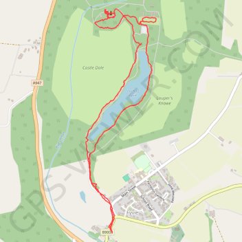
Fyvie Castle and Loch of Fyvie
- Distance: 5.2 Km
- Elevation gain: 55 m
- Maximum elevation: 67 m
- Elevation loss: 55 m
- Minimum elevation: 50 m
- Moving time: 1 h 11 m
- Moving speed: 4.3 Km/h
- Maximum speed: 29.8 Km/h
- Total time: 2 h 57 m
- Global speed: 1.7 Km/h
Interactive trail map
Trail profile
- Distance: 5.2 Km
- Elevation gain: 55 m
- Maximum elevation: 67 m
- Elevation loss: 55 m
- Minimum elevation: 50 m
- Moving time: 1 h 11 m
- Moving speed: 4.3 Km/h
- Maximum speed: 29.8 Km/h
- Total time: 2 h 57 m
- Global speed: 1.7 Km/h
About this trail
Name: Fyvie Castle and Loch of Fyvie trail, distance, elevation, map, profile, GPS track
Start: B9005, Fyvie, Aberdeenshire, Scotland, AB53 8PZ, United Kingdom (57.42950 -2.39477)
End: B9005, Fyvie, Aberdeenshire, Scotland, AB53 8PZ, United Kingdom (57.42976 -2.39512)
Coordinates: 57.42944 -2.39790 57.44373 -2.38958
Other hiking, mountain biking, running and outdoor activity trails
Click on a trail to view its statistics, map and profile.
Huntly Castle
United Kingdom > Scotland > Moray > Dufftown
Distance: 86.3 Km • Elevation gain: 826 m • Maximum elevation: 298 m