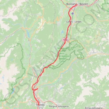
2022_DE_Bozen-Trient | flach
- Distance: 65.7 Km
- Elevation gain: 300 m
- Maximum elevation: 274 m
- Elevation loss: 370 m
- Minimum elevation: 190 m
Interactive trail map
Trail profile
- Distance: 65.7 Km
- Elevation gain: 300 m
- Maximum elevation: 274 m
- Elevation loss: 370 m
- Minimum elevation: 190 m
About this trail
Name: 2022_DE_Bozen-Trient | flach trail, distance, elevation, map, profile, GPS track
Coordinates: 46.06606 11.07560 46.49787 11.35447
Other hiking, mountain biking, running and outdoor activity trails
Click on a trail to view its statistics, map and profile.
Riva del Garda - Pergine Valsugana
Italy > Trentino – Alto Adige/Südtirol > Provincia di Trento > Riva del Garda > Sant'Alessandro > Alboletta
One-way between Riva del Garda and Pergine Valsugana.
Distance: 193.3 Km • Elevation gain: 5,511 m • Maximum elevation: 2,038 m
2022_DE_Trient-Riva del Garda
Italy > Trentino – Alto Adige/Südtirol > Provincia di Trento > Trento
Distance: 51.1 Km • Elevation gain: 377 m • Maximum elevation: 276 m