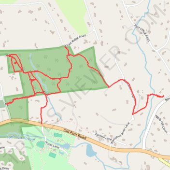
Old Field Preserve Trails
- Distance: 6.3 Km
- Elevation gain: 134 m
- Maximum elevation: 209 m
- Elevation loss: 107 m
- Minimum elevation: 139 m
- Moving time: 1 h 31 m
- Moving speed: 4.1 Km/h
- Maximum speed: 8.7 Km/h
- Total time: 1 h 38 m
- Global speed: 3.8 Km/h
Interactive trail map
Trail profile
- Distance: 6.3 Km
- Elevation gain: 134 m
- Maximum elevation: 209 m
- Elevation loss: 107 m
- Minimum elevation: 139 m
- Moving time: 1 h 31 m
- Moving speed: 4.1 Km/h
- Maximum speed: 8.7 Km/h
- Total time: 1 h 38 m
- Global speed: 3.8 Km/h
About this trail
Name: Old Field Preserve Trails trail, distance, elevation, map, profile, GPS track
Coordinates: 41.27757 -73.59305 41.28440 -73.57454
Other hiking, mountain biking, running and outdoor activity trails
Click on a trail to view its statistics, map and profile.