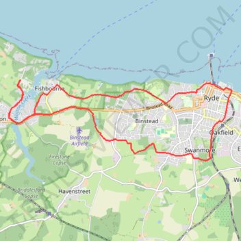
Ryde loop - Isle of Wight
- Distance: 16.4 Km
- Elevation gain: 237 m
- Maximum elevation: 53 m
- Elevation loss: 237 m
- Minimum elevation: 0 m
- Moving time: 1 h 35 m
- Moving speed: 10.4 Km/h
- Maximum speed: 14.7 Km/h
- Total time: 1 h 35 m
- Global speed: 10.4 Km/h
Interactive trail map
Trail profile
- Distance: 16.4 Km
- Elevation gain: 237 m
- Maximum elevation: 53 m
- Elevation loss: 237 m
- Minimum elevation: 0 m
- Moving time: 1 h 35 m
- Moving speed: 10.4 Km/h
- Maximum speed: 14.7 Km/h
- Total time: 1 h 35 m
- Global speed: 10.4 Km/h
About this trail
Name: Ryde loop - Isle of Wight trail, distance, elevation, map, profile, GPS track
Start: New Road, Wootton Bridge, Isle of Wight, England, PO33 4JP, United Kingdom (50.73361 -1.22406)
End: New Road, Wootton Bridge, Isle of Wight, England, PO33 4JP, United Kingdom (50.73357 -1.22409)
Coordinates: 50.71659 -1.22806 50.73364 -1.15346
Other hiking, mountain biking, running and outdoor activity trails
Click on a trail to view its statistics, map and profile.
Hovertravel Ryde to Southsea
United Kingdom > England > Isle of Wight > Ryde
Distance: 7.3 Km • Elevation gain: 2 m • Maximum elevation: 2 m