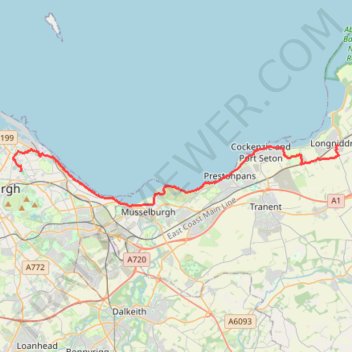
Ride from Longniddry to Edinburgh via Port Seton, Cockenzie, Prestonpans, Levenhall Links, Fisherrow, Joppa and Portobello
- Distance: 24.1 Km
- Elevation gain: 146 m
- Maximum elevation: 46 m
- Elevation loss: 144 m
- Minimum elevation: 0 m
- Moving time: 1 h 50 m
- Moving speed: 13.1 Km/h
- Maximum speed: 30.9 Km/h
- Total time: 2 h 7 m
- Global speed: 11.4 Km/h
Interactive trail map
Trail profile
- Distance: 24.1 Km
- Elevation gain: 146 m
- Maximum elevation: 46 m
- Elevation loss: 144 m
- Minimum elevation: 0 m
- Moving time: 1 h 50 m
- Moving speed: 13.1 Km/h
- Maximum speed: 30.9 Km/h
- Total time: 2 h 7 m
- Global speed: 11.4 Km/h
About this trail
Name: Ride from Longniddry to Edinburgh via Port Seton, Cockenzie, Prestonpans, Levenhall Links, Fisherrow, Joppa and Portobello trail, distance, elevation, map, profile, GPS track
Coordinates: 55.94445 -3.16928 55.97357 -2.89118
Other hiking, mountain biking, running and outdoor activity trails
Click on a trail to view its statistics, map and profile.
Edinburgh - Leith
United Kingdom > Scotland > City of Edinburgh
Distance: 12.6 Km • Elevation gain: 140 m • Maximum elevation: 59 m