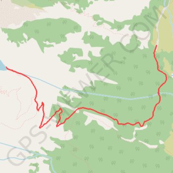
Delta Lake via Amphitheater Lake Trail
- Distance: 11.2 Km
- Elevation gain: 713 m
- Maximum elevation: 2,757 m
- Elevation loss: 711 m
- Minimum elevation: 2,052 m
Interactive trail map
Trail profile
- Distance: 11.2 Km
- Elevation gain: 713 m
- Maximum elevation: 2,757 m
- Elevation loss: 711 m
- Minimum elevation: 2,052 m
About this trail
Name: Delta Lake via Amphitheater Lake Trail trail, distance, elevation, map, profile, GPS track
Start: Valley Trail, Teton County, Wyoming, United States (43.73407 -110.74168)
End: Lupine Meadows Trailhead, Apex Trail, Teton County, Wyoming, United States (43.73537 -110.74123)
Coordinates: 43.72336 -110.77131 43.73537 -110.73921
Other hiking, mountain biking, running and outdoor activity trails
Click on a trail to view its statistics, map and profile.
Delta Lake from Lupine Meadows Trailhead in Grand Teton National Park
United States > Wyoming > Teton County
This hike to Delta Lake is a challenging but rewarding adventure through stunning alpine scenery in Grand Teton National Park. Although the trail isn’t officially maintained, making the final stretch a bit tricky with some boulder scrambling, the crystal-clear lake at the top is absolutely worth the effort.…
Distance: 12.3 Km • Elevation gain: 730 m • Maximum elevation: 2,759 m