Black Butte summit
Afternoon hike
- Distance: 8.1 Km
- Elevation gain: 472 m
- Maximum elevation: 1,949 m
- Elevation loss: 570 m
- Minimum elevation: 1,388 m
- Moving time: 2 h 5 m
- Moving speed: 3.9 Km/h
- Maximum speed: 27.9 Km/h
- Total time: 2 h 35 m
- Global speed: 3.1 Km/h
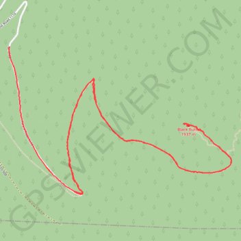
Interactive trail map
Trail profile
- Distance: 8.1 Km
- Elevation gain: 472 m
- Maximum elevation: 1,949 m
- Elevation loss: 570 m
- Minimum elevation: 1,388 m
- Moving time: 2 h 5 m
- Moving speed: 3.9 Km/h
- Maximum speed: 27.9 Km/h
- Total time: 2 h 35 m
- Global speed: 3.1 Km/h
About this trail
Name: Black Butte summit trail, distance, elevation, map, profile, GPS track
End: Forest Road 1110, Jefferson County, Oregon, 97730, United States (44.40587 -121.65497)
Coordinates: 44.39494 -121.65501 44.40587 -121.63194
Other hiking, mountain biking, running and outdoor activity trails
Click on a trail to view its statistics, map and profile.
Northern part of the Pacific Crest Trail (PCT)
United States > Oregon > Klamath County
Hike on the Pacific Crest National Scenic Trail from Crater Lake to Canada Border through Oregon and Washington along the Sierra Nevada and Cascade mountain ranges. #Hiking #Mountain #SierraNevada #Cascade #Nature #Forest #Park #PCT
Distance: 1,198.3 Km • Elevation gain: 44,308 m • Maximum elevation: 2,307 m