Rando découverte : refuge de l'étendard, glacier de Saint Sorlin et recherche d'une brèche dans les massifs rocheux afin de pouvoir y aller depuis l'alpe d'Huez lors d'une prochaine expédition. Retour à la voiture juste avant la tombée de nuit après s'êt
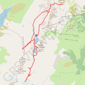
- Distance: 26.2 Km
- Elevation gain: 1,366 m
- Maximum elevation: 2,738 m
- Elevation loss: 1,365 m
- Minimum elevation: 2,057 m
- Moving time: 7 h 12 m
- Moving speed: 3.6 Km/h
- Maximum speed: 32.7 Km/h
- Total time: 9 h 21 m
- Global speed: 2.8 Km/h
Interactive trail map
Trail profile
- Distance: 26.2 Km
- Elevation gain: 1,366 m
- Maximum elevation: 2,738 m
- Elevation loss: 1,365 m
- Minimum elevation: 2,057 m
- Moving time: 7 h 12 m
- Moving speed: 3.6 Km/h
- Maximum speed: 32.7 Km/h
- Total time: 9 h 21 m
- Global speed: 2.8 Km/h
About this trail
Name: Rando découverte : refuge de l'étendard, glacier de Saint Sorlin et recherche d'une brèche dans les massifs rocheux afin de pouvoir y aller depuis l'alpe d'Huez lors d'une prochaine expédition. Retour à la voiture juste avant la tombée de nuit après s'êt trail, distance, elevation, map, profile, GPS track
Coordinates: 45.16877 6.16069 45.22814 6.20407
Other hiking, mountain biking, running and outdoor activity trails
Click on a trail to view its statistics, map and profile.
PT23DS2 Lörrach → Cadaqués
Germany > Baden-Württemberg > Landkreis Lörrach > Lörrach (Kernstadt)
Distance: 1,050.7 Km • Elevation gain: 13,130 m • Maximum elevation: 1,505 m
Trail de l’Étendard - 44km
France > Auvergne-Rhône-Alpes > Isère > Le Bourg-d'Oisans > Le Bassey
Distance: 45.0 Km • Elevation gain: 3,160 m • Maximum elevation: 2,726 m