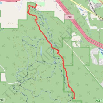
Rattlesnake Mountain to Grand Prospect
- Distance: 13.9 Km
- Elevation gain: 650 m
- Maximum elevation: 934 m
- Elevation loss: 650 m
- Minimum elevation: 321 m
- Moving time: 3 h 46 m
- Moving speed: 3.7 Km/h
- Maximum speed: 35.8 Km/h
- Total time: 4 h 19 m
- Global speed: 3.2 Km/h
Interactive trail map
Trail profile
- Distance: 13.9 Km
- Elevation gain: 650 m
- Maximum elevation: 934 m
- Elevation loss: 650 m
- Minimum elevation: 321 m
- Moving time: 3 h 46 m
- Moving speed: 3.7 Km/h
- Maximum speed: 35.8 Km/h
- Total time: 4 h 19 m
- Global speed: 3.2 Km/h
About this trail
Name: Rattlesnake Mountain to Grand Prospect trail, distance, elevation, map, profile, GPS track
Coordinates: 47.47140 -121.84966 47.50986 -121.82089
Other hiking, mountain biking, running and outdoor activity trails
Click on a trail to view its statistics, map and profile.
Northern part of the Pacific Crest Trail (PCT)
United States > Oregon > Klamath County
Hike on the Pacific Crest National Scenic Trail from Crater Lake to Canada Border through Oregon and Washington along the Sierra Nevada and Cascade mountain ranges. #Hiking #Mountain #SierraNevada #Cascade #Nature #Forest #Park #PCT
Distance: 1,198.3 Km • Elevation gain: 44,308 m • Maximum elevation: 2,307 m