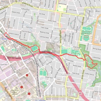
Artarmon Reserve - Flat Rock Gully
Interactive trail map
Trail profile
- Distance: 6.3 Km
- Elevation gain: 102 m
- Maximum elevation: 87 m
- Elevation loss: 102 m
- Minimum elevation: 20 m
- Moving time: 1 h 31 m
- Moving speed: 4.1 Km/h
- Maximum speed: 11.2 Km/h
- Total time: 1 h 37 m
- Global speed: 3.8 Km/h
About this trail
Name: Artarmon Reserve - Flat Rock Gully trail, distance, elevation, map, profile, GPS track
Coordinates: -33.81590 151.18447 -33.80797 151.20915
Other hiking, mountain biking, running and outdoor activity trails
Click on a trail to view its statistics, map and profile.