Laurel Falls Trail in Great Smoky Mountains National Park
The Laurel Falls Trail offers a delightful experience as it leads hikers through a picturesque landscape filled with vibrant mountain laurel blooms in spring. The trail, while moderately challenging with some steep sections, is mostly paved, making it accessible for a wide range of visitors. Upon reaching the falls, you can enjoy stunning views of the upper and lower cascades from a scenic wooden bridge, creating a perfect spot for photography and relaxation. #Hiking #Waterfall #Forest #Nature
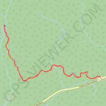
- Distance: 4.1 Km
- Elevation gain: 208 m
- Maximum elevation: 822 m
- Elevation loss: 207 m
- Minimum elevation: 707 m
- Moving time: 58 m 21 s
- Moving speed: 4.2 Km/h
- Maximum speed: 6.6 Km/h
- Total time: 1 h 4 m
- Global speed: 3.9 Km/h
Interactive trail map
Trail profile
- Distance: 4.1 Km
- Elevation gain: 208 m
- Maximum elevation: 822 m
- Elevation loss: 207 m
- Minimum elevation: 707 m
- Moving time: 58 m 21 s
- Moving speed: 4.2 Km/h
- Maximum speed: 6.6 Km/h
- Total time: 1 h 4 m
- Global speed: 3.9 Km/h
About this trail
Name: Laurel Falls Trail in Great Smoky Mountains National Park trail, distance, elevation, map, profile, GPS track
Coordinates: 35.67161 -83.59322 35.67757 -83.58030
Other hiking, mountain biking, running and outdoor activity trails
Click on a trail to view its statistics, map and profile.
Great Smoky Mountains Appalachian Trail
United States > North Carolina > Clay County
Hike through Great Smoky Mountains along Appalachian Trail via Standing Indian, Ridgepole Mountain, Yellow Bald, Wine Spring Bald, Copper Ridge Bald, Cheoah Bald, Wauchecha Bald, Fontana Dam, Thunderhead Mountain, Clingmans Dome, Mount Kephart and Mount Guyot. #Hiking #Mountain #Nature #Forest #Lake…
Distance: 231.7 Km • Elevation gain: 8,873 m • Maximum elevation: 2,013 m