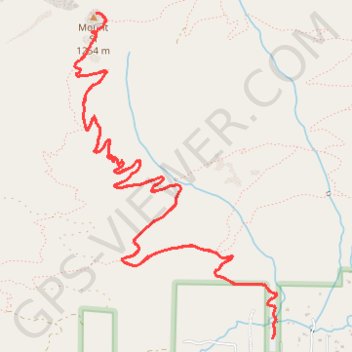
Mount Si
From the Mount Si Trailhead, the route enters the forested lower slopes of the Mount Si Natural Resources Conservation Area and follows the main Mount Si Trail into a steady switchbacking ascent above North Bend.
After the first wooded climb, it passes through Snag Flat, an old-growth forest section, then continues higher through steeper forest, small openings and talus-side views toward the Snoqualmie Valley.
The hike finishes at the rocky summit area below the Haystack, where the forest gives way to broad views over North Bend, the Snoqualmie Valley, the Cascades and, in clear weather, more distant western and southern horizons.
#Hiking #Mountain #Forest #Nature #Summit #Rock #Valley
- Distance: 12.3 Km
- Elevation gain: 1,043 m
- Maximum elevation: 1,229 m
- Elevation loss: 1,043 m
- Minimum elevation: 209 m
Interactive trail map
Trail profile
- Distance: 12.3 Km
- Elevation gain: 1,043 m
- Maximum elevation: 1,229 m
- Elevation loss: 1,043 m
- Minimum elevation: 209 m
About this trail
Name: Mount Si trail, distance, elevation, map, profile, GPS track
Coordinates: 47.48782 -121.74076 47.50719 -121.72288
Other hiking, mountain biking, running and outdoor activity trails
Click on a trail to view its statistics, map and profile.
Mount Si Trail in Mount Si Natural Resources Conservation Area
United States > Washington > King County
The Mount Si Trail offers an exhilarating journey through a vibrant forest, leading you to breathtaking panoramic views of the surrounding Cascade Mountains, the picturesque Snoqualmie Valley and Mount Rainier emerging in the distance. With each step, you’re embraced by nature’s beauty, from the soothing…
Distance: 12.9 Km • Elevation gain: 1,039 m • Maximum elevation: 1,228 m
Mount Si Trail in Mount Si Natural Resources Conservation Area
United States > Washington > King County
Mount Si Trail, one of the most iconic hikes in the Pacific Northwest, offers hikers a steady ascent through dense forests and occasional open areas revealing breathtaking vistas. As you climb, you'll pass through old-growth sections, where towering trees and lush foliage set the stage for stunning views of…
Distance: 12.2 Km • Elevation gain: 1,018 m • Maximum elevation: 1,193 m
Mount Si Trail and Mount Teneriffe Trail Loop
United States > Washington > King County
The loop hike via Mount Si and Mount Teneriffe Trails provides an exceptional experience in the Mount Si Natural Resources Conservation Area. The route offers a mix of dense, lush forests and sweeping vistas, including views of Mount Rainier, Rattlesnake Ridge, and the surrounding Cascades. Hikers will…
Distance: 14.0 Km • Elevation gain: 1,014 m • Maximum elevation: 1,205 m
Northern part of the Pacific Crest Trail (PCT)
United States > Oregon > Klamath County
Hike on the Pacific Crest National Scenic Trail from Crater Lake to Canada Border through Oregon and Washington along the Sierra Nevada and Cascade mountain ranges. #Hiking #Mountain #SierraNevada #Cascade #Nature #Forest #Park #PCT
Distance: 1,198.3 Km • Elevation gain: 44,308 m • Maximum elevation: 2,307 m
Old Mount Si Trail
United States > Washington > King County > North Bend
Distance: 13.3 Km • Elevation gain: 1,085 m • Maximum elevation: 1,153 m
Track (8/12/23, 7:47:57AM)
United States > Washington > King County
Distance: 57.9 Km • Elevation gain: 3,713 m • Maximum elevation: 1,404 m