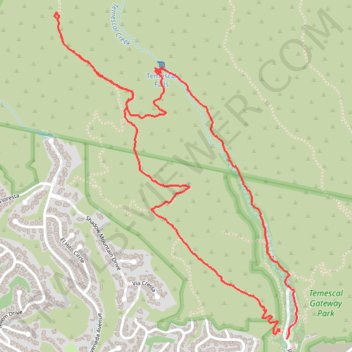
Skull Rock and Temescal Falls Loop
Loop hike to Skull Rock and Temescal Falls via Temescal Ridge Trail and Temescal Canyon Trail in Topanga State Park #Hiking #Mountain #Forest #Loop #Rock #Waterfall #Ocean
- Distance: 6.5 Km
- Elevation gain: 339 m
- Maximum elevation: 427 m
- Elevation loss: 349 m
- Minimum elevation: 110 m
- Moving time: 1 h 33 m
- Moving speed: 4.2 Km/h
- Maximum speed: 8.4 Km/h
- Total time: 1 h 42 m
- Global speed: 3.8 Km/h
Interactive trail map
Trail profile
- Distance: 6.5 Km
- Elevation gain: 339 m
- Maximum elevation: 427 m
- Elevation loss: 349 m
- Minimum elevation: 110 m
- Moving time: 1 h 33 m
- Moving speed: 4.2 Km/h
- Maximum speed: 8.4 Km/h
- Total time: 1 h 42 m
- Global speed: 3.8 Km/h
About this trail
Name: Skull Rock and Temescal Falls Loop trail, distance, elevation, map, profile, GPS track
Coordinates: 34.05439 -118.54298 34.07084 -118.52821
Other hiking, mountain biking, running and outdoor activity trails
Click on a trail to view its statistics, map and profile.
Skull Rock and Temescal Falls Loop in Topanga State Park
United States > California > Los Angeles County > Los Angeles
The Skull Rock and Temescal Falls Loop in Topanga State Park offers hikers a diverse experience, featuring lush shaded trails, exposed steep climbs, and gorgeous ocean views. Along the route, you'll encounter the intriguing Skull Rock formation, which resembles a skull, and a small cascade known as Temescal…
Distance: 6.7 Km • Elevation gain: 335 m • Maximum elevation: 427 m