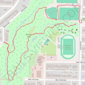
Mahon Park loop walk
- Distance: 2.0 Km
- Elevation gain: 42 m
- Maximum elevation: 74 m
- Elevation loss: 39 m
- Minimum elevation: 31 m
- Moving time: 37 m 36 s
- Moving speed: 3.3 Km/h
- Maximum speed: 8.2 Km/h
- Total time: 1 h 4 m
- Global speed: 1.9 Km/h
Interactive trail map
Trail profile
- Distance: 2.0 Km
- Elevation gain: 42 m
- Maximum elevation: 74 m
- Elevation loss: 39 m
- Minimum elevation: 31 m
- Moving time: 37 m 36 s
- Moving speed: 3.3 Km/h
- Maximum speed: 8.2 Km/h
- Total time: 1 h 4 m
- Global speed: 1.9 Km/h
About this trail
Name: Mahon Park loop walk trail, distance, elevation, map, profile, GPS track
Coordinates: 49.32216 -123.08837 49.32646 -123.08151
Other hiking, mountain biking, running and outdoor activity trails
Click on a trail to view its statistics, map and profile.