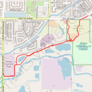
Willow Bend Natural Area
- Distance: 4.8 Km
- Elevation gain: 37 m
- Maximum elevation: 1,506 m
- Elevation loss: 27 m
- Minimum elevation: 1,493 m
- Moving time: 28 m 55 s
- Moving speed: 10.1 Km/h
- Maximum speed: 26.7 Km/h
- Total time: 31 m 8 s
- Global speed: 9.3 Km/h
Interactive trail map
Trail profile
- Distance: 4.8 Km
- Elevation gain: 37 m
- Maximum elevation: 1,506 m
- Elevation loss: 27 m
- Minimum elevation: 1,493 m
- Moving time: 28 m 55 s
- Moving speed: 10.1 Km/h
- Maximum speed: 26.7 Km/h
- Total time: 31 m 8 s
- Global speed: 9.3 Km/h
About this trail
Name: Willow Bend Natural Area trail, distance, elevation, map, profile, GPS track
Coordinates: 40.38369 -105.05419 40.39325 -105.03673
Other hiking, mountain biking, running and outdoor activity trails
Click on a trail to view its statistics, map and profile.
Willow Bend Natural Area Loop
United States > Colorado > Larimer County > Loveland
Distance: 2.2 Km • Elevation gain: 22 m • Maximum elevation: 1,505 m