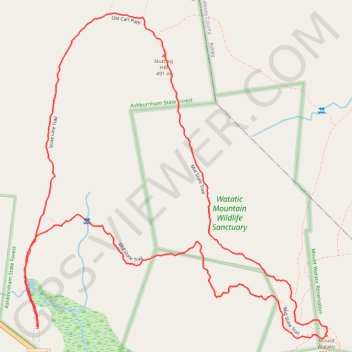
Mount Watatic and Nutting Hill Loop via Wapack Trail, Mid State Trail and State Line Trail in Watatic Mountain Wildlife Sanctuary
The Mount Watatic Loop offers a beautiful New England hiking experience, combining forested paths with rewarding summit views. Following the Wapack, Mid State, and State Line trails, the route brings you to the peak of Mount Watatic, where on clear days, you can enjoy wide vistas stretching from Mount Monadnock in the north to Mount Wachusett in the south. Birdwatchers often frequent this trail in fall for the hawk migration, adding to the natural appeal of this moderately challenging hike. #Hiking #Loop #Forest #Nature
- Distance: 4.6 Km
- Elevation gain: 203 m
- Maximum elevation: 545 m
- Elevation loss: 202 m
- Minimum elevation: 373 m
- Moving time: 1 h 5 m
- Moving speed: 4.2 Km/h
- Maximum speed: 9.8 Km/h
- Total time: 1 h 5 m
- Global speed: 4.2 Km/h
Interactive trail map
Trail profile
- Distance: 4.6 Km
- Elevation gain: 203 m
- Maximum elevation: 545 m
- Elevation loss: 202 m
- Minimum elevation: 373 m
- Moving time: 1 h 5 m
- Moving speed: 4.2 Km/h
- Maximum speed: 9.8 Km/h
- Total time: 1 h 5 m
- Global speed: 4.2 Km/h
About this trail
Name: Mount Watatic and Nutting Hill Loop via Wapack Trail, Mid State Trail and State Line Trail in Watatic Mountain Wildlife Sanctuary trail, distance, elevation, map, profile, GPS track
Coordinates: 42.69664 -71.90494 42.70644 -71.89253