Thank you for supporting this site ❤️
Make a donation
Make a donation
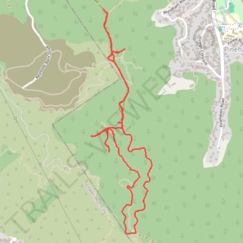
2025-02-02_13-54_Sun
- Distance: 5.4 Km
- Elevation gain: 212 m
- Maximum elevation: 334 m
- Elevation loss: 213 m
- Minimum elevation: 216 m
- Moving time: 1 h 12 m
- Moving speed: 4.5 Km/h
- Maximum speed: 9.4 Km/h
- Total time: 1 h 22 m
- Global speed: 3.9 Km/h
Interactive trail map
Thank you for supporting this site ❤️
Make a donation
Make a donation
Trail profile
- Distance: 5.4 Km
- Elevation gain: 212 m
- Maximum elevation: 334 m
- Elevation loss: 213 m
- Minimum elevation: 216 m
- Moving time: 1 h 12 m
- Moving speed: 4.5 Km/h
- Maximum speed: 9.4 Km/h
- Total time: 1 h 22 m
- Global speed: 3.9 Km/h
Thank you for supporting this site ❤️
Make a donation
Make a donation
About this trail
Name: 2025-02-02_13-54_Sun trail, distance, elevation, map, profile, GPS track
Coordinates: -41.17405 175.00241 -41.15902 175.00788
Thank you for supporting this site ❤️
Make a donation
Make a donation