Thank you for supporting this site ❤️
Make a donation
Make a donation
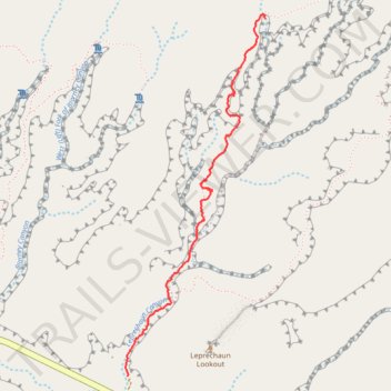
2026-03-20_13-10_Fri
- Distance: 2.6 Km
- Elevation gain: 171 m
- Maximum elevation: 1,520 m
- Elevation loss: 17 m
- Minimum elevation: 1,361 m
- Moving time: 50 m 41 s
- Moving speed: 3.0 Km/h
- Maximum speed: 6.2 Km/h
- Total time: 1 h 13 m
- Global speed: 2.1 Km/h
Interactive trail map
Thank you for supporting this site ❤️
Make a donation
Make a donation
Trail profile
- Distance: 2.6 Km
- Elevation gain: 171 m
- Maximum elevation: 1,520 m
- Elevation loss: 17 m
- Minimum elevation: 1,361 m
- Moving time: 50 m 41 s
- Moving speed: 3.0 Km/h
- Maximum speed: 6.2 Km/h
- Total time: 1 h 13 m
- Global speed: 2.1 Km/h
Thank you for supporting this site ❤️
Make a donation
Make a donation
About this trail
Name: 2026-03-20_13-10_Fri trail, distance, elevation, map, profile, GPS track
Start: Leprechaun Canyon Trail, Garfield County, Utah, United States (38.01855 -110.53695)
Coordinates: 38.01855 -110.53705 38.03538 -110.52881
Thank you for supporting this site ❤️
Make a donation
Make a donation
Other hiking, mountain biking, running and outdoor activity trails
Click on a trail to view its statistics, map and profile.
Blarney Canyon - Hiking / canyoning
United States > Utah > Garfield County
Distance: 2.1 Km • Elevation gain: 93 m • Maximum elevation: 1,497 m