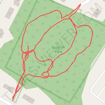
Grafton Park Loop
- Distance: 1.1 Km
- Elevation gain: 11 m
- Maximum elevation: 126 m
- Elevation loss: 15 m
- Minimum elevation: 118 m
- Moving time: 14 m 35 s
- Moving speed: 4.3 Km/h
- Maximum speed: 6.0 Km/h
- Total time: 14 m 35 s
- Global speed: 4.3 Km/h
Interactive trail map
Trail profile
- Distance: 1.1 Km
- Elevation gain: 11 m
- Maximum elevation: 126 m
- Elevation loss: 15 m
- Minimum elevation: 118 m
- Moving time: 14 m 35 s
- Moving speed: 4.3 Km/h
- Maximum speed: 6.0 Km/h
- Total time: 14 m 35 s
- Global speed: 4.3 Km/h
About this trail
Name: Grafton Park Loop trail, distance, elevation, map, profile, GPS track
Coordinates: 40.85069 -74.46211 40.85225 -74.46040