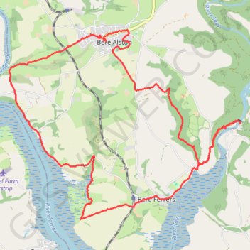
Lopwell Dam - Bere Alston
- Distance: 20.8 Km
- Elevation gain: 553 m
- Maximum elevation: 153 m
- Elevation loss: 555 m
- Minimum elevation: -1 m
Interactive trail map
Trail profile
- Distance: 20.8 Km
- Elevation gain: 553 m
- Maximum elevation: 153 m
- Elevation loss: 555 m
- Minimum elevation: -1 m
About this trail
Name: Lopwell Dam - Bere Alston trail, distance, elevation, map, profile, GPS track
Start: Tidal walkway, Bere Ferrers, West Devon, Devon, England, PL6 7BZ, United Kingdom (50.46546 -4.15147)
Coordinates: 50.44712 -4.21717 50.48189 -4.15047