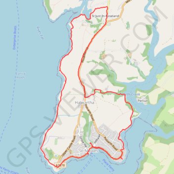
St. Mawes Loop
Loop hike from St. Mawes via St Mawes Castle, St Just-In-Roseland, Halwartha and Porth Creek in the Cornwall National Landscape. #Hiking #Loop #Nature #Countryside #Sea #Channel #Coast #River
- Distance: 12.4 Km
- Elevation gain: 235 m
- Maximum elevation: 82 m
- Elevation loss: 235 m
- Minimum elevation: 0 m
- Moving time: 3 h 31 m
- Moving speed: 3.5 Km/h
- Maximum speed: 18.4 Km/h
- Total time: 4 h 6 m
- Global speed: 3.0 Km/h
Interactive trail map
Trail profile
- Distance: 12.4 Km
- Elevation gain: 235 m
- Maximum elevation: 82 m
- Elevation loss: 235 m
- Minimum elevation: 0 m
- Moving time: 3 h 31 m
- Moving speed: 3.5 Km/h
- Maximum speed: 18.4 Km/h
- Total time: 4 h 6 m
- Global speed: 3.0 Km/h
About this trail
Name: St. Mawes Loop trail, distance, elevation, map, profile, GPS track
Coordinates: 50.15558 -5.02811 50.18436 -5.00238