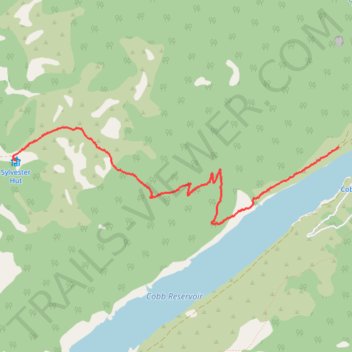
Lake Sylvester Hut from the Cobb Dam
- Distance: 5.4 Km
- Elevation gain: 519 m
- Maximum elevation: 1,329 m
- Elevation loss: 46 m
- Minimum elevation: 824 m
- Moving time: 1 h 49 m
- Moving speed: 3.0 Km/h
- Maximum speed: 5.1 Km/h
- Total time: 2 h 37 m
- Global speed: 2.1 Km/h
Interactive trail map
Trail profile
- Distance: 5.4 Km
- Elevation gain: 519 m
- Maximum elevation: 1,329 m
- Elevation loss: 46 m
- Minimum elevation: 824 m
- Moving time: 1 h 49 m
- Moving speed: 3.0 Km/h
- Maximum speed: 5.1 Km/h
- Total time: 2 h 37 m
- Global speed: 2.1 Km/h
About this trail
Name: Lake Sylvester Hut from the Cobb Dam trail, distance, elevation, map, profile, GPS track
Start: 2181, Cobb Dam Road, New Zealand (-41.10491 172.68336)
End: Sylvester Hut, BULLOCK TRACK, New Zealand (-41.10618 172.64440)
Coordinates: -41.11194 172.64402 -41.10311 172.68336
Other hiking, mountain biking, running and outdoor activity trails
Click on a trail to view its statistics, map and profile.