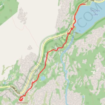
Hike from Tenaya Lake to Olmsted Point
- Distance: 7.9 Km
- Elevation gain: 123 m
- Maximum elevation: 2,570 m
- Elevation loss: 123 m
- Minimum elevation: 2,486 m
- Moving time: 1 h 53 m
- Moving speed: 4.2 Km/h
- Maximum speed: 5.7 Km/h
- Total time: 2 h 15 m
- Global speed: 3.5 Km/h
Interactive trail map
Trail profile
- Distance: 7.9 Km
- Elevation gain: 123 m
- Maximum elevation: 2,570 m
- Elevation loss: 123 m
- Minimum elevation: 2,486 m
- Moving time: 1 h 53 m
- Moving speed: 4.2 Km/h
- Maximum speed: 5.7 Km/h
- Total time: 2 h 15 m
- Global speed: 3.5 Km/h
About this trail
Name: Hike from Tenaya Lake to Olmsted Point trail, distance, elevation, map, profile, GPS track
Start: Tioga Road, Mariposa County, California, United States (37.83307 -119.46537)
End: Tioga Road, Mariposa County, California, United States (37.83308 -119.46446)
Coordinates: 37.80897 -119.48518 37.83314 -119.46446
Other hiking, mountain biking, running and outdoor activity trails
Click on a trail to view its statistics, map and profile.
Clouds Rest from Tenaya Lake
United States > California > Mariposa County
From the Sunrise Lakes Trailhead beside Tenaya Lake, the route leaves Tioga Road and moves quickly from the open lakeshore into lodgepole forest and granite slabs, following the southbound trail signed for Clouds Rest and Sunrise before climbing away from the basin above Tenaya Creek. Beyond the Sunrise Lakes…
Distance: 19.3 Km • Elevation gain: 881 m • Maximum elevation: 2,991 m
Clouds Rest Trail in Yosemite National Park
United States > California > Mariposa County
The Clouds Rest Trail in Yosemite offers hikers a rewarding, strenuous challenge with breathtaking views throughout. As you ascend, the landscape transforms from lush forest to open granite ridgelines, with expansive vistas of Tenaya Lake and the iconic Half Dome in the distance. The final approach to the…
Distance: 20.3 Km • Elevation gain: 873 m • Maximum elevation: 2,991 m