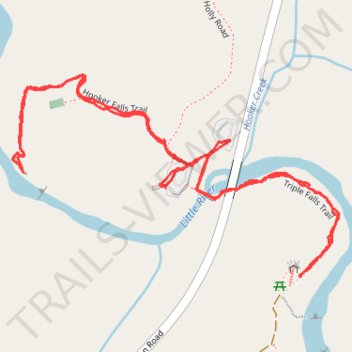
Hooker Falls Trail and Triple Falls Trail
- Distance: 3.0 Km
- Elevation gain: 82 m
- Maximum elevation: 724 m
- Elevation loss: 82 m
- Minimum elevation: 689 m
- Moving time: 40 m 39 s
- Moving speed: 4.4 Km/h
- Maximum speed: 14.4 Km/h
- Total time: 1 h 49 m
- Global speed: 1.6 Km/h
Interactive trail map
Trail profile
- Distance: 3.0 Km
- Elevation gain: 82 m
- Maximum elevation: 724 m
- Elevation loss: 82 m
- Minimum elevation: 689 m
- Moving time: 40 m 39 s
- Moving speed: 4.4 Km/h
- Maximum speed: 14.4 Km/h
- Total time: 1 h 49 m
- Global speed: 1.6 Km/h
About this trail
Name: Hooker Falls Trail and Triple Falls Trail trail, distance, elevation, map, profile, GPS track
Start: Staton Road, Transylvania County, North Carolina, 28766, United States (35.20264 -82.61950)
End: Hooker Ridge Road, Transylvania County, North Carolina, 28718, United States (35.20254 -82.61959)
Coordinates: 35.20030 -82.62404 35.20408 -82.61659
Other hiking, mountain biking, running and outdoor activity trails
Click on a trail to view its statistics, map and profile.
Triple Falls Trail and High Falls Trail in Dupont State Recreational Forest
United States > North Carolina > Transylvania County
The Triple Falls and High Falls Trails in Dupont State Recreational Forest offer hikers a scenic journey through lush forests, leading to the impressive Triple Falls—a three-tiered cascade featured in films like "The Hunger Games"—and culminating at the majestic High Falls, a 150-foot waterfall that slides…
Distance: 3.7 Km • Elevation gain: 109 m • Maximum elevation: 762 m