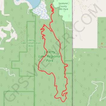
Liberty Lake Loop via Zephyr Connecter
Evening hike in Liberty Lake Regional Park
- Distance: 19.4 Km
- Elevation gain: 739 m
- Maximum elevation: 1,125 m
- Elevation loss: 738 m
- Minimum elevation: 632 m
- Moving time: 4 h 6 m
- Moving speed: 4.7 Km/h
- Maximum speed: 10.2 Km/h
- Total time: 5 h 15 m
- Global speed: 3.7 Km/h
Interactive trail map
Trail profile
- Distance: 19.4 Km
- Elevation gain: 739 m
- Maximum elevation: 1,125 m
- Elevation loss: 738 m
- Minimum elevation: 632 m
- Moving time: 4 h 6 m
- Moving speed: 4.7 Km/h
- Maximum speed: 10.2 Km/h
- Total time: 5 h 15 m
- Global speed: 3.7 Km/h
About this trail
Name: Liberty Lake Loop via Zephyr Connecter trail, distance, elevation, map, profile, GPS track
End: Zephyr Connector, Spokane County, Washington, United States (47.63548 -117.05563)
Coordinates: 47.58922 -117.06518 47.63575 -117.04446