Little Snowy Top via Salmo-Priest Loop
Morning hike at Salmo-Priest Loop
- Distance: 31.1 Km
- Elevation gain: 1,403 m
- Maximum elevation: 2,071 m
- Elevation loss: 1,398 m
- Minimum elevation: 1,241 m
- Moving time: 7 h 35 m
- Moving speed: 4.1 Km/h
- Maximum speed: 25.0 Km/h
- Total time: 23 h 27 m
- Global speed: 1.3 Km/h
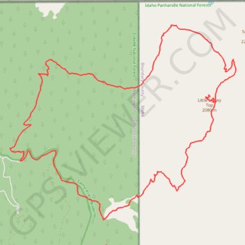
Interactive trail map
Trail profile
- Distance: 31.1 Km
- Elevation gain: 1,403 m
- Maximum elevation: 2,071 m
- Elevation loss: 1,398 m
- Minimum elevation: 1,241 m
- Moving time: 7 h 35 m
- Moving speed: 4.1 Km/h
- Maximum speed: 25.0 Km/h
- Total time: 23 h 27 m
- Global speed: 1.3 Km/h
About this trail
Name: Little Snowy Top via Salmo-Priest Loop trail, distance, elevation, map, profile, GPS track
Start: Sullivan Creek Road, Pend Oreille County, Washington, United States (48.95580 -117.08100)
End: Sullivan Creek Road, Pend Oreille County, Washington, United States (48.95555 -117.08113)
Coordinates: 48.93968 -117.08579 48.99275 -116.99195
Other hiking, mountain biking, running and outdoor activity trails
Click on a trail to view its statistics, map and profile.
Salmo-Priest Loop
United States > Washington > Pend Oreille County
Distance: 29.9 Km • Elevation gain: 1,376 m • Maximum elevation: 1,965 m