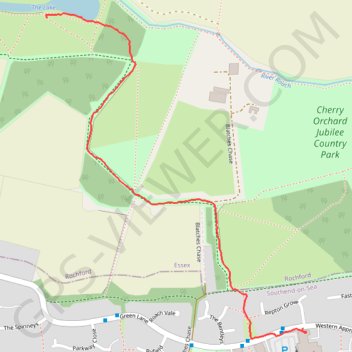
The Lake
Foot
- Distance: 1.4 Km
- Elevation gain: 15 m
- Maximum elevation: 32 m
- Elevation loss: 14 m
- Minimum elevation: 18 m
- Moving time: 18 m 55 s
- Moving speed: 4.5 Km/h
- Maximum speed: 6.6 Km/h
- Total time: 23 m 38 s
- Global speed: 3.6 Km/h
Interactive trail map
Trail profile
- Distance: 1.4 Km
- Elevation gain: 15 m
- Maximum elevation: 32 m
- Elevation loss: 14 m
- Minimum elevation: 18 m
- Moving time: 18 m 55 s
- Moving speed: 4.5 Km/h
- Maximum speed: 6.6 Km/h
- Total time: 23 m 38 s
- Global speed: 3.6 Km/h
About this trail
Name: The Lake trail, distance, elevation, map, profile, GPS track
Coordinates: 51.57123 0.66239 51.57818 0.67133
Other hiking, mountain biking, running and outdoor activity trails
Click on a trail to view its statistics, map and profile.
Edward's Hall Park - The Lake
United Kingdom > England > Essex > Rochford
Foot
Distance: 1.4 Km • Elevation gain: 4 m • Maximum elevation: 44 m