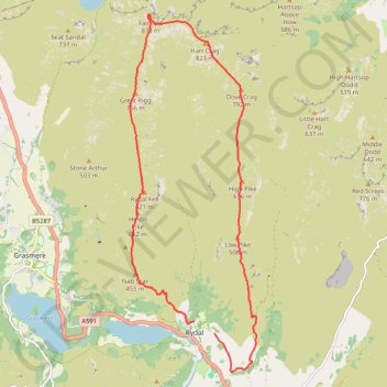
Fairfield Horseshoe Loop
- Distance: 16.0 Km
- Elevation gain: 931 m
- Maximum elevation: 870 m
- Elevation loss: 919 m
- Minimum elevation: 69 m
- Moving time: 4 h 51 m
- Moving speed: 3.3 Km/h
- Maximum speed: 8.6 Km/h
- Total time: 7 h 13 m
- Global speed: 2.2 Km/h
Interactive trail map
Trail profile
- Distance: 16.0 Km
- Elevation gain: 931 m
- Maximum elevation: 870 m
- Elevation loss: 919 m
- Minimum elevation: 69 m
- Moving time: 4 h 51 m
- Moving speed: 3.3 Km/h
- Maximum speed: 8.6 Km/h
- Total time: 7 h 13 m
- Global speed: 2.2 Km/h
About this trail
Name: Fairfield Horseshoe Loop trail, distance, elevation, map, profile, GPS track
Coordinates: 54.44087 -2.99699 54.49723 -2.96276
Other hiking, mountain biking, running and outdoor activity trails
Click on a trail to view its statistics, map and profile.
Rydal Cave, Grasmere and Rydal Water Loop
United Kingdom > England > Westmorland and Furness > Rydal
Distance: 11.2 Km • Elevation gain: 307 m • Maximum elevation: 140 m
Loughrigg Fell loop from Ambleside
United Kingdom > England > Westmorland and Furness > Ambleside
Distance: 12.7 Km • Elevation gain: 489 m • Maximum elevation: 329 m
Rydal Water and Grasmere
United Kingdom > England > Westmorland and Furness > Ambleside
Distance: 15.9 Km • Elevation gain: 337 m • Maximum elevation: 140 m
Ambleside to Rydal Loop
United Kingdom > England > Westmorland and Furness > Ambleside
Distance: 8.7 Km • Elevation gain: 252 m • Maximum elevation: 198 m
Rydal Adventure Lab
United Kingdom > England > Westmorland and Furness > Rydal
Distance: 2.7 Km • Elevation gain: 70 m • Maximum elevation: 94 m
Rydal Sculpture trail
United Kingdom > England > Westmorland and Furness > Rydal
Distance: 1.4 Km • Elevation gain: 41 m • Maximum elevation: 115 m