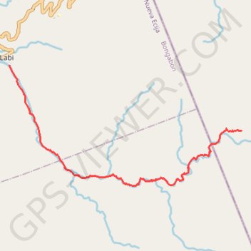
Labi Trail
File with points/tracks from Locus Map/4.24.3
- Distance: 10.8 Km
- Elevation gain: 277 m
- Maximum elevation: 874 m
- Elevation loss: 882 m
- Minimum elevation: 266 m
- Moving time: 3 h 32 m
- Moving speed: 3.1 Km/h
- Maximum speed: 7.4 Km/h
- Total time: 20 h 30 m
- Global speed: 0.5 Km/h
Interactive trail map
Trail profile
- Distance: 10.8 Km
- Elevation gain: 277 m
- Maximum elevation: 874 m
- Elevation loss: 882 m
- Minimum elevation: 266 m
- Moving time: 3 h 32 m
- Moving speed: 3.1 Km/h
- Maximum speed: 7.4 Km/h
- Total time: 20 h 30 m
- Global speed: 0.5 Km/h
About this trail
Name: Labi Trail trail, distance, elevation, map, profile, GPS track
Start: Aurora, Central Luzon, Philippines (15.62568 121.32947)
End: Labi, Bongabon, Nueva Ecija, Central Luzon, 3128, Philippines (15.64225 121.26876)
Coordinates: 15.61178 121.26870 15.64225 121.32949