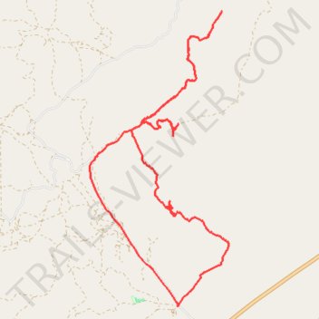
Eagle Mountain canyons
- Distance: 20.8 Km
- Elevation gain: 730 m
- Maximum elevation: 1,908 m
- Elevation loss: 731 m
- Minimum elevation: 1,452 m
- Moving time: 2 h 45 m
- Moving speed: 7.5 Km/h
- Maximum speed: 33.5 Km/h
- Total time: 3 h 24 m
- Global speed: 6.1 Km/h
Interactive trail map
Trail profile
- Distance: 20.8 Km
- Elevation gain: 730 m
- Maximum elevation: 1,908 m
- Elevation loss: 731 m
- Minimum elevation: 1,452 m
- Moving time: 2 h 45 m
- Moving speed: 7.5 Km/h
- Maximum speed: 33.5 Km/h
- Total time: 3 h 24 m
- Global speed: 6.1 Km/h
About this trail
Name: Eagle Mountain canyons trail, distance, elevation, map, profile, GPS track
Start: Soldiers Pass Road, Utah County, Utah, United States (40.17397 -111.94550)
End: Soldiers Pass Road, Utah County, Utah, United States (40.17378 -111.94558)
Coordinates: 40.17378 -111.96572 40.22529 -111.93391