Goat Rock Viewpoint Loop via Goat Rock Trail in Hot Springs National Park
The Goat Rock Viewpoint Loop offers hikers a relatively short but rewarding trek through dense forests. Along the route, you can enjoy views of unique rock formations, particularly the novaculite outcrops, as well as sweeping vistas of the Ouachita Mountains. The highlight of the trail is the overlook, where the forest opens up to provide panoramic views of the surrounding area, including the town of Hot Springs in the distance. #Hiking #Loop #Mountain #Forest #Nature
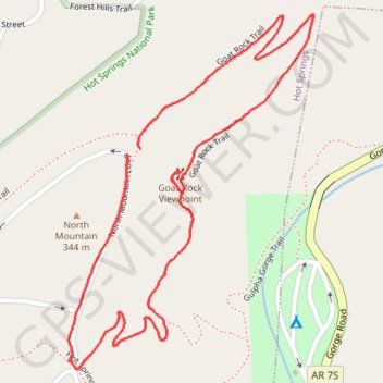
- Distance: 2.6 Km
- Elevation gain: 112 m
- Maximum elevation: 323 m
- Elevation loss: 105 m
- Minimum elevation: 242 m
- Moving time: 41 m 35 s
- Moving speed: 3.8 Km/h
- Maximum speed: 9.4 Km/h
- Total time: 50 m 14 s
- Global speed: 3.1 Km/h
Interactive trail map
Trail profile
- Distance: 2.6 Km
- Elevation gain: 112 m
- Maximum elevation: 323 m
- Elevation loss: 105 m
- Minimum elevation: 242 m
- Moving time: 41 m 35 s
- Moving speed: 3.8 Km/h
- Maximum speed: 9.4 Km/h
- Total time: 50 m 14 s
- Global speed: 3.1 Km/h
About this trail
Name: Goat Rock Viewpoint Loop via Goat Rock Trail in Hot Springs National Park trail, distance, elevation, map, profile, GPS track
Start: Goat Rock Trail, Hot Springs, Garland County, Arkansas, 71901, United States (34.52773 -93.04008)
Coordinates: 34.52358 -93.04174 34.53028 -93.03611