Newquay to Penhale Sands
- Distance: 28.9 Km
- Elevation gain: 711 m
- Maximum elevation: 88 m
- Elevation loss: 708 m
- Minimum elevation: 0 m
- Moving time: 6 h 56 m
- Moving speed: 4.2 Km/h
- Maximum speed: 20.4 Km/h
- Total time: 7 h 53 m
- Global speed: 3.7 Km/h
Interactive trail map
Trail profile
- Distance: 28.9 Km
- Elevation gain: 711 m
- Maximum elevation: 88 m
- Elevation loss: 708 m
- Minimum elevation: 0 m
- Moving time: 6 h 56 m
- Moving speed: 4.2 Km/h
- Maximum speed: 20.4 Km/h
- Total time: 7 h 53 m
- Global speed: 3.7 Km/h
About this trail
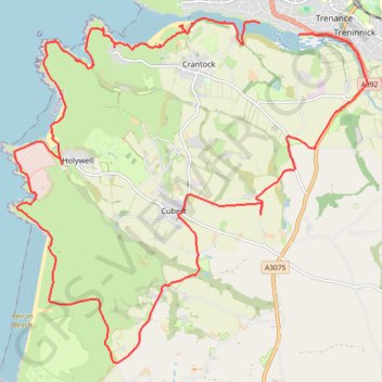
Name: Newquay to Penhale Sands trail, distance, elevation, map, profile, GPS track
Start: Trevean Way, Trenance, Newquay, Cornwall, England, TR7 1TW, United Kingdom (50.40781 -5.09537)
End: Gannel Road, Trenance, Newquay, Cornwall, England, TR7 2AU, United Kingdom (50.40608 -5.08609)
Coordinates: 50.35584 -5.15426 50.40861 -5.06966
Other hiking, mountain biking, running and outdoor activity trails
Click on a trail to view its statistics, map and profile.
Around Perranporth
United Kingdom > England > Cornwall > Perranzabuloe
Distance: 23.1 Km • Elevation gain: 867 m • Maximum elevation: 102 m
Perranporth
United Kingdom > England > Cornwall > Goonhavern > Rosehill
Distance: 14.2 Km • Elevation gain: 569 m • Maximum elevation: 97 m