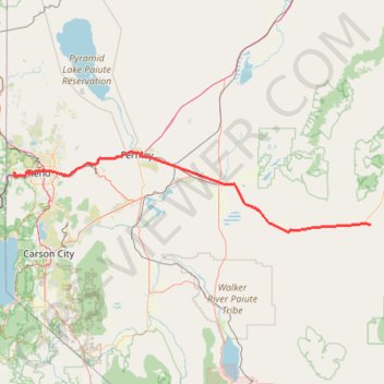
Day 1: Home to dispersed camping 60 mi E of Austin, NV
- Distance: 208.4 Km
- Elevation gain: 1,012 m
- Maximum elevation: 1,563 m
- Elevation loss: 1,033 m
- Minimum elevation: 1,195 m
Interactive trail map
Trail profile
- Distance: 208.4 Km
- Elevation gain: 1,012 m
- Maximum elevation: 1,563 m
- Elevation loss: 1,033 m
- Minimum elevation: 1,195 m
About this trail
Name: Day 1: Home to dispersed camping 60 mi E of Austin, NV trail, distance, elevation, map, profile, GPS track
Start: 9175, Bay Meadows Drive, Reno, Washoe County, Nevada, 89523, United States (39.52770 -119.95025)
End: Carroll Summit Road, Eastgate, Churchill County, Nevada, United States (39.29861 -117.91186)
Coordinates: 39.26428 -119.95114 39.61816 -117.91166
Other hiking, mountain biking, running and outdoor activity trails
Click on a trail to view its statistics, map and profile.
Third Creek Pond Loop via Tahoe Rim Trail in Humboldt-Toiyabe National Forest
United States > Nevada > Washoe County
The Third Creek Pond Loop via the Tahoe Rim Trail offers a picturesque hiking experience in the Humboldt-Toiyabe National Forest. This moderately challenging trail takes you through a variety of landscapes, from the serene Third Creek Pond to the surrounding pine forests, with occasional views of distant…
Distance: 16.0 Km • Elevation gain: 592 m • Maximum elevation: 3,086 m
Mount Rose via Tahoe Rim Trail and Rim to Rose in Humboldt-Toiyabe National Forest
United States > Nevada > Washoe County
Mount Rose via the Tahoe Rim Trail is a long and rewarding hike that gradually takes you through scenic meadows and past Galena Falls before reaching the final steep ascent. The climb to the summit is tough, but the sweeping views of Lake Tahoe and the surrounding peaks make it all worthwhile. It’s a perfect…
Distance: 18.2 Km • Elevation gain: 794 m • Maximum elevation: 3,277 m
Hunter Creek Trail in Mount Rose Wilderness
United States > Nevada > Washoe County
The Hunter Creek Trail is a delightful hike that takes you through diverse landscapes. Starting out under the open sun, the trail quickly transitions into a serene forest where you can enjoy the nature leading up to a stunning waterfall. This peaceful spot is perfect for a break, making the hike a rewarding…
Distance: 9.9 Km • Elevation gain: 403 m • Maximum elevation: 1,878 m
MTB Loop via Golden Fleece and Total Recall Trail in Peavine Mountain
United States > Nevada > Washoe County > Reno
Distance: 31.6 Km • Elevation gain: 918 m • Maximum elevation: 2,015 m
Hunter Footill Road Loop in Humboldt-Toiyabe National Forest
United States > Nevada > Washoe County
Distance: 21.0 Km • Elevation gain: 548 m • Maximum elevation: 1,720 m
Tahoe Rim Trail (TRT) - Marlette Peak - Incline Flume
United States > Nevada > Washoe County > Incline Village-Crystal Bay
Distance: 46.5 Km • Elevation gain: 1,381 m • Maximum elevation: 2,690 m
Tahoe Rim Trail (TRT) - Marlette Peak - Flumes
United States > Nevada > Washoe County > Incline Village-Crystal Bay
Distance: 49.7 Km • Elevation gain: 1,411 m • Maximum elevation: 2,690 m
Tahoe Rim to Washoe from Mount Rose Highway
United States > Nevada > Washoe County
Distance: 28.5 Km • Elevation gain: 1,481 m • Maximum elevation: 2,842 m
Upper Whites Creek Trail
United States > Nevada > Washoe County
Distance: 2.9 Km • Elevation gain: 188 m • Maximum elevation: 2,020 m
Dry Pond Trail
United States > Nevada > Washoe County
Distance: 3.6 Km • Elevation gain: 107 m • Maximum elevation: 2,124 m