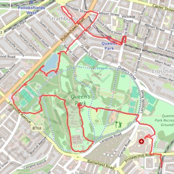
Glasgow Queen's Park Walk
- Distance: 5.4 Km
- Elevation gain: 68 m
- Maximum elevation: 66 m
- Elevation loss: 80 m
- Minimum elevation: 22 m
- Moving time: 2 h 5 m
- Moving speed: 2.6 Km/h
- Maximum speed: 6.5 Km/h
- Total time: 6 h 58 m
- Global speed: 0.8 Km/h
Interactive trail map
Trail profile
- Distance: 5.4 Km
- Elevation gain: 68 m
- Maximum elevation: 66 m
- Elevation loss: 80 m
- Minimum elevation: 22 m
- Moving time: 2 h 5 m
- Moving speed: 2.6 Km/h
- Maximum speed: 6.5 Km/h
- Total time: 6 h 58 m
- Global speed: 0.8 Km/h
About this trail
Name: Glasgow Queen's Park Walk trail, distance, elevation, map, profile, GPS track
Coordinates: 55.82704 -4.27807 55.83738 -4.26091
Other hiking, mountain biking, running and outdoor activity trails
Click on a trail to view its statistics, map and profile.
Johnstone, Scotland to Paisley via Glasgow
United Kingdom > Scotland > Renfrewshire > Johnstone
Bike
Distance: 65.2 Km • Elevation gain: 458 m • Maximum elevation: 53 m
Critical Mass Glasgow Loop Bike
United Kingdom > Scotland > Glasgow City > Glasgow
Distance: 13.0 Km • Elevation gain: 74 m • Maximum elevation: 29 m
Critical Mass Glasgow
United Kingdom > Scotland > Glasgow City > Glasgow
Bike
Distance: 20.0 Km • Elevation gain: 150 m • Maximum elevation: 37 m
Critical Mass Glasgow
United Kingdom > Scotland > Glasgow City > Glasgow
Bike
Distance: 14.8 Km • Elevation gain: 102 m • Maximum elevation: 36 m