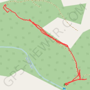
Forest path in Gidleigh #1
- Distance: 0.9 Km
- Elevation gain: 12 m
- Maximum elevation: 305 m
- Elevation loss: 41 m
- Minimum elevation: 270 m
- Moving time: 15 m 9 s
- Moving speed: 3.7 Km/h
- Maximum speed: 23.1 Km/h
- Total time: 33 m 7 s
- Global speed: 1.7 Km/h
Interactive trail map
Trail profile
- Distance: 0.9 Km
- Elevation gain: 12 m
- Maximum elevation: 305 m
- Elevation loss: 41 m
- Minimum elevation: 270 m
- Moving time: 15 m 9 s
- Moving speed: 3.7 Km/h
- Maximum speed: 23.1 Km/h
- Total time: 33 m 7 s
- Global speed: 1.7 Km/h
About this trail
Name: Forest path in Gidleigh #1 trail, distance, elevation, map, profile, GPS track
Start: Gidleigh, West Devon, Devon, England, TQ13 8HS, United Kingdom (50.67394 -3.88687)
Coordinates: 50.67193 -3.88712 50.67411 -3.88356
Other hiking, mountain biking, running and outdoor activity trails
Click on a trail to view its statistics, map and profile.
Gidleigh Kestor Rocks
United Kingdom > England > Devon > West Devon > Chagford > Teigncombe
Distance: 5.7 Km • Elevation gain: 232 m • Maximum elevation: 428 m