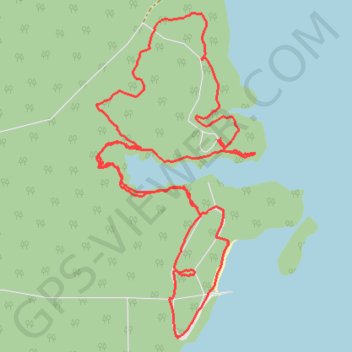
Trails and roads around Bayview and Horseshoe Cove Campgrounds
Bayview Loop Trail, viewpoint, Horseshoe Bay campground
- Distance: 5.4 Km
- Elevation gain: 93 m
- Maximum elevation: 247 m
- Elevation loss: 92 m
- Minimum elevation: 215 m
- Moving time: 1 h 22 m
- Moving speed: 3.9 Km/h
- Maximum speed: 7.1 Km/h
- Total time: 1 h 30 m
- Global speed: 3.6 Km/h
Interactive trail map
Trail profile
- Distance: 5.4 Km
- Elevation gain: 93 m
- Maximum elevation: 247 m
- Elevation loss: 92 m
- Minimum elevation: 215 m
- Moving time: 1 h 22 m
- Moving speed: 3.9 Km/h
- Maximum speed: 7.1 Km/h
- Total time: 1 h 30 m
- Global speed: 3.6 Km/h
About this trail
Name: Trails and roads around Bayview and Horseshoe Cove Campgrounds trail, distance, elevation, map, profile, GPS track
Start: Bayview Loop Trail, Whatcom County, Washington, United States (48.67493 -121.67648)
Coordinates: 48.66823 -121.68282 48.67915 -121.67475
Other hiking, mountain biking, running and outdoor activity trails
Click on a trail to view its statistics, map and profile.
Northern part of the Pacific Crest Trail (PCT)
United States > Oregon > Klamath County
Hike on the Pacific Crest National Scenic Trail from Crater Lake to Canada Border through Oregon and Washington along the Sierra Nevada and Cascade mountain ranges. #Hiking #Mountain #SierraNevada #Cascade #Nature #Forest #Park #PCT
Distance: 1,198.3 Km • Elevation gain: 44,308 m • Maximum elevation: 2,307 m