Simons Wood
Wokingham Trail Running
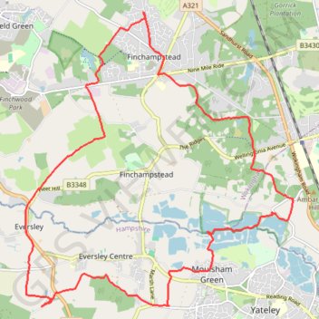
- Distance: 19.9 Km
- Elevation gain: 147 m
- Maximum elevation: 104 m
- Elevation loss: 147 m
- Minimum elevation: 49 m
- Moving time: 2 h 10 m
- Moving speed: 9.1 Km/h
- Maximum speed: 16.6 Km/h
- Total time: 2 h 12 m
- Global speed: 9.0 Km/h
Interactive trail map
Trail profile
- Distance: 19.9 Km
- Elevation gain: 147 m
- Maximum elevation: 104 m
- Elevation loss: 147 m
- Minimum elevation: 49 m
- Moving time: 2 h 10 m
- Moving speed: 9.1 Km/h
- Maximum speed: 16.6 Km/h
- Total time: 2 h 12 m
- Global speed: 9.0 Km/h
About this trail
Name: Simons Wood trail, distance, elevation, map, profile, GPS track
Coordinates: 51.34064 -0.88885 51.38700 -0.82144
Other hiking, mountain biking, running and outdoor activity trails
Click on a trail to view its statistics, map and profile.
Hogwood Park
United Kingdom > England > Borough of Wokingham > Arborfield Green
Distance: 1.5 Km • Elevation gain: 7 m • Maximum elevation: 58 m