Turkey Mountain Loop via Yellow Trail in Turkey Mountain Urban Wilderness Area
The Turkey Mountain Loop via the Yellow Trail offers a moderately challenging hike through Tulsa’s natural landscapes, complete with forested paths, rocky stretches, and scenic overlooks of the Arkansas River. This loop winds through diverse terrain, providing a rewarding mix of tranquility and rugged beauty, while features like Vista Point give hikers a chance to pause and appreciate the sweeping views over the city. Its proximity to Tulsa makes it a popular trail for both locals and visitors seeking an accessible yet immersive wilderness experience. #Hiking #Loop #Overlook #River #Forest #Nature
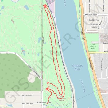
- Distance: 6.4 Km
- Elevation gain: 124 m
- Maximum elevation: 275 m
- Elevation loss: 123 m
- Minimum elevation: 214 m
- Moving time: 1 h 30 m
- Moving speed: 4.2 Km/h
- Maximum speed: 8.0 Km/h
- Total time: 1 h 30 m
- Global speed: 4.2 Km/h
Interactive trail map
Trail profile
- Distance: 6.4 Km
- Elevation gain: 124 m
- Maximum elevation: 275 m
- Elevation loss: 123 m
- Minimum elevation: 214 m
- Moving time: 1 h 30 m
- Moving speed: 4.2 Km/h
- Maximum speed: 8.0 Km/h
- Total time: 1 h 30 m
- Global speed: 4.2 Km/h
About this trail
Name: Turkey Mountain Loop via Yellow Trail in Turkey Mountain Urban Wilderness Area trail, distance, elevation, map, profile, GPS track
Start: Little Loop, Tulsa, Tulsa County, Oklahoma, 74132, United States (36.06540 -95.99257)
End: Little Loop, Tulsa, Tulsa County, Oklahoma, 74132, United States (36.06544 -95.99253)
Coordinates: 36.06540 -95.99340 36.08449 -95.98843