Monte Sano Mountain Loop via Sinks Trail, Stone Cuts Trail and North Plateau Loop
The Monte Sano Mountain Loop offers an invigorating hike through diverse terrain and striking features. The loop showcases impressive rock formations and limestone cliffs, particularly along the Stone Cuts Trail, where hikers are enveloped by towering stone walls. Along the way, views open up to expansive mountain vistas, offering glimpses of Huntsville and the surrounding landscape. Expect a mix of challenging rocky sections, serene forested areas, and scenic outlooks, making it a rewarding route for both experienced and casual hikers. #Hiking #Loop #Forest #Nature
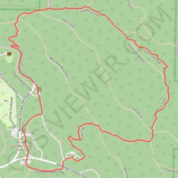
- Distance: 4.0 Km
- Elevation gain: 157 m
- Maximum elevation: 497 m
- Elevation loss: 156 m
- Minimum elevation: 406 m
- Moving time: 59 m 9 s
- Moving speed: 4.1 Km/h
- Maximum speed: 9.3 Km/h
- Total time: 1 h 19 m
- Global speed: 3.0 Km/h
Interactive trail map
Trail profile
- Distance: 4.0 Km
- Elevation gain: 157 m
- Maximum elevation: 497 m
- Elevation loss: 156 m
- Minimum elevation: 406 m
- Moving time: 59 m 9 s
- Moving speed: 4.1 Km/h
- Maximum speed: 9.3 Km/h
- Total time: 1 h 19 m
- Global speed: 3.0 Km/h
About this trail
Name: Monte Sano Mountain Loop via Sinks Trail, Stone Cuts Trail and North Plateau Loop trail, distance, elevation, map, profile, GPS track
Start: Sinks Trail, Huntsville, Madison County, Alabama, 35811, United States (34.74413 -86.50832)
End: Bikers, Sinks Trail, Huntsville, Madison County, Alabama, 35811, United States (34.74408 -86.50833)
Coordinates: 34.74334 -86.51241 34.75211 -86.50204
Other hiking, mountain biking, running and outdoor activity trails
Click on a trail to view its statistics, map and profile.
South Plateau MTB Loop
United States > Alabama > Madison County > Huntsville
Distance: 9.9 Km • Elevation gain: 144 m • Maximum elevation: 503 m
25 mile Bike Ride, Huntsville/Gurley AL
United States > Alabama > Madison County > Huntsville > Five Points
Moontown Airport
Distance: 40.5 Km • Elevation gain: 377 m • Maximum elevation: 307 m
McKay Trail/Monte Sano State Park (MSSP) ride
United States > Alabama > Madison County > Huntsville
Distance: 14.4 Km • Elevation gain: 323 m • Maximum elevation: 502 m
Monte Sano Loop Ride
United States > Alabama > Madison County > Huntsville
Afternoon Mountain Bike Ride
Distance: 13.0 Km • Elevation gain: 284 m • Maximum elevation: 492 m
Warpath Ridge MTB Trail
United States > Alabama > Madison County > Huntsville
Distance: 7.2 Km • Elevation gain: 31 m • Maximum elevation: 499 m
Land Trust Ride
United States > Alabama > Madison County > Huntsville
Distance: 19.0 Km • Elevation gain: 481 m • Maximum elevation: 494 m
Tally-Ho Trail
United States > Alabama > Madison County > Huntsville
Distance: 1.0 Km • Elevation gain: 7 m • Maximum elevation: 489 m