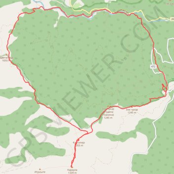
Studena planina
- Distance: 18.3 Km
- Elevation gain: 855 m
- Maximum elevation: 1,348 m
- Elevation loss: 859 m
- Minimum elevation: 651 m
- Moving time: 6 h 10 m
- Moving speed: 3.0 Km/h
- Maximum speed: 10.8 Km/h
- Total time: 9 h 50 s
- Global speed: 2.0 Km/h
Interactive trail map
Trail profile
- Distance: 18.3 Km
- Elevation gain: 855 m
- Maximum elevation: 1,348 m
- Elevation loss: 859 m
- Minimum elevation: 651 m
- Moving time: 6 h 10 m
- Moving speed: 3.0 Km/h
- Maximum speed: 10.8 Km/h
- Total time: 9 h 50 s
- Global speed: 2.0 Km/h
About this trail
Name: Studena planina trail, distance, elevation, map, profile, GPS track
Coordinates: 43.51831 20.65536 43.55882 20.71101
Other hiking, mountain biking, running and outdoor activity trails
Click on a trail to view its statistics, map and profile.
2022_Yu
Slovenia > Ajdovščina > Žapuže
Distance: 2,457.3 Km • Elevation gain: 32,048 m • Maximum elevation: 1,950 m
Studena planina,Stojanac,Zli Čukar, Kavgalija,Karaula
Serbia > Central Serbia > Raska Administrative District > Brezna > Cvetne Livade
Distance: 17.4 Km • Elevation gain: 825 m • Maximum elevation: 1,349 m