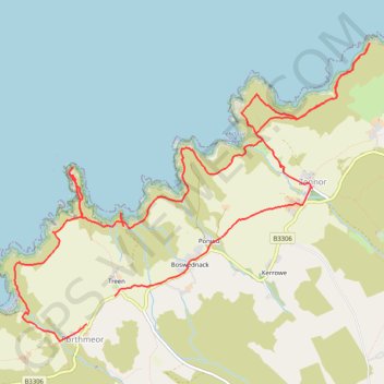
Porthmeor Zennor Loop Hike
- Distance: 14.8 Km
- Elevation gain: 634 m
- Maximum elevation: 125 m
- Elevation loss: 631 m
- Minimum elevation: 0 m
- Moving time: 4 h 41 m
- Moving speed: 3.2 Km/h
- Maximum speed: 28.1 Km/h
- Total time: 5 h 42 m
- Global speed: 2.6 Km/h
Interactive trail map
Trail profile
- Distance: 14.8 Km
- Elevation gain: 634 m
- Maximum elevation: 125 m
- Elevation loss: 631 m
- Minimum elevation: 0 m
- Moving time: 4 h 41 m
- Moving speed: 3.2 Km/h
- Maximum speed: 28.1 Km/h
- Total time: 5 h 42 m
- Global speed: 2.6 Km/h
About this trail
Name: Porthmeor Zennor Loop Hike trail, distance, elevation, map, profile, GPS track
Start: B3306, Treen, Zennor, Porthmeor, Cornwall, England, TR26 3DE, United Kingdom (50.17978 -5.59749)
End: B3306, Treen, Zennor, Porthmeor, Cornwall, England, TR26 3DE, United Kingdom (50.18214 -5.59374)
Coordinates: 50.17826 -5.60714 50.20381 -5.55970
Other hiking, mountain biking, running and outdoor activity trails
Click on a trail to view its statistics, map and profile.
Pendeen to Porthmeor
United Kingdom > England > Cornwall > St Just > Boscaswell
Distance: 17.6 Km • Elevation gain: 578 m • Maximum elevation: 140 m