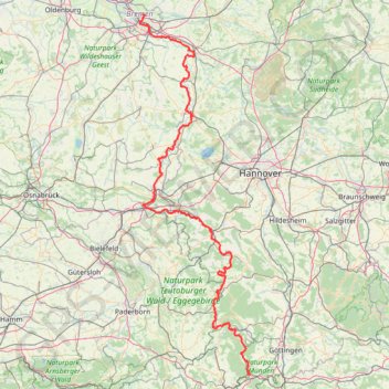
Weser-Radweg on GPSies.com
- Distance: 395.1 Km
- Elevation gain: 2,442 m
- Maximum elevation: 215 m
- Elevation loss: 2,583 m
- Minimum elevation: 2 m
- Moving time: 1 d 15 h
- Moving speed: 9.9 Km/h
- Maximum speed: 10.9 Km/h
- Total time: 1 d 15 h
- Global speed: 9.9 Km/h
Interactive trail map
Trail profile
- Distance: 395.1 Km
- Elevation gain: 2,442 m
- Maximum elevation: 215 m
- Elevation loss: 2,583 m
- Minimum elevation: 2 m
- Moving time: 1 d 15 h
- Moving speed: 9.9 Km/h
- Maximum speed: 10.9 Km/h
- Total time: 1 d 15 h
- Global speed: 9.9 Km/h
About this trail
Name: Weser-Radweg on GPSies.com trail, distance, elevation, map, profile, GPS track
End: 1, Hochschulring, Lehe, Horn-Lehe, Bremen-Ost, Bremen, 28359, Germany (53.11440 8.83333)
Coordinates: 51.41256 8.80689 53.11505 9.65863
Other hiking, mountain biking, running and outdoor activity trails
Click on a trail to view its statistics, map and profile.
Görlitz - Alpen
Germany > Saxony > Görlitz > Görlitz
Distance: 749.5 Km • Elevation gain: 5,160 m • Maximum elevation: 446 m
Görlitz - Alpen
Germany > Saxony > Görlitz > Görlitz
Distance: 749.5 Km • Elevation gain: 5,160 m • Maximum elevation: 446 m
Track vom: 2020-06-13 07:00
Germany > North Rhine-Westphalia > Kreis Wesel > Schermbeck
Distance: 679.9 Km • Elevation gain: 5,301 m • Maximum elevation: 921 m
Track vom: 2020-06-27 07:26
Germany > Bavaria > Landkreis Ostallgäu > Halblech
Distance: 688.1 Km • Elevation gain: 4,307 m • Maximum elevation: 911 m
PT23BS1 Kiel → Lörrach
Germany > Schleswig-Holstein > Kiel
Distance: 1,046.7 Km • Elevation gain: 9,265 m • Maximum elevation: 757 m
Dag 3 BRemerweg tot Lattrop
Germany > Lower Saxony > Landkreis Celle > Celle
Distance: 277.0 Km • Elevation gain: 643 m • Maximum elevation: 80 m