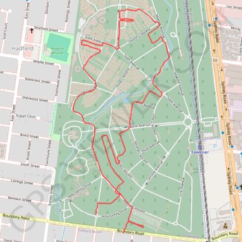
Paths and highways in Fawkner Memorial Park
- Distance: 4.1 Km
- Elevation gain: 21 m
- Maximum elevation: 78 m
- Elevation loss: 19 m
- Minimum elevation: 70 m
- Moving time: 23 m 34 s
- Moving speed: 10.5 Km/h
- Maximum speed: 20.8 Km/h
- Total time: 23 m 34 s
- Global speed: 10.5 Km/h
Interactive trail map
Trail profile
- Distance: 4.1 Km
- Elevation gain: 21 m
- Maximum elevation: 78 m
- Elevation loss: 19 m
- Minimum elevation: 70 m
- Moving time: 23 m 34 s
- Moving speed: 10.5 Km/h
- Maximum speed: 20.8 Km/h
- Total time: 23 m 34 s
- Global speed: 10.5 Km/h
About this trail
Name: Paths and highways in Fawkner Memorial Park trail, distance, elevation, map, profile, GPS track
Coordinates: -37.71862 144.95321 -37.70839 144.95875
Other hiking, mountain biking, running and outdoor activity trails
Click on a trail to view its statistics, map and profile.
Melbourne Bike Ride
Australia > Victoria > Melbourne
Distance: 45.2 Km • Elevation gain: 272 m • Maximum elevation: 111 m