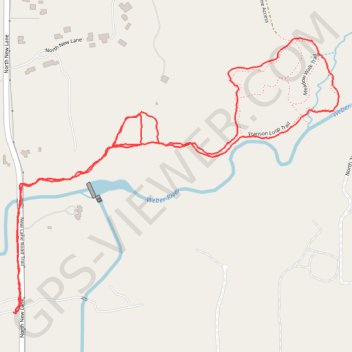
New Lane to Franson Loop
- Distance: 4.0 Km
- Elevation gain: 23 m
- Maximum elevation: 1,996 m
- Elevation loss: 22 m
- Minimum elevation: 1,976 m
- Moving time: 55 m 35 s
- Moving speed: 4.3 Km/h
- Maximum speed: 21.8 Km/h
- Total time: 56 m 22 s
- Global speed: 4.3 Km/h
Interactive trail map
Trail profile
- Distance: 4.0 Km
- Elevation gain: 23 m
- Maximum elevation: 1,996 m
- Elevation loss: 22 m
- Minimum elevation: 1,976 m
- Moving time: 55 m 35 s
- Moving speed: 4.3 Km/h
- Maximum speed: 21.8 Km/h
- Total time: 56 m 22 s
- Global speed: 4.3 Km/h
About this trail
Name: New Lane to Franson Loop trail, distance, elevation, map, profile, GPS track
Start: North New Lane, Oakley, Summit County, Utah, United States (40.71244 -111.28136)
End: North New Lane, Oakley, Summit County, Utah, United States (40.71245 -111.28122)
Coordinates: 40.71239 -111.28136 40.72026 -111.26909