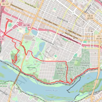
A bike ride in part to survey the new North Bank Trail section next to Hollywood
- Distance: 13.9 Km
- Elevation gain: 180 m
- Maximum elevation: 74 m
- Elevation loss: 180 m
- Minimum elevation: 25 m
Interactive trail map
Trail profile
- Distance: 13.9 Km
- Elevation gain: 180 m
- Maximum elevation: 74 m
- Elevation loss: 180 m
- Minimum elevation: 25 m
About this trail
Name: A bike ride in part to survey the new North Bank Trail section next to Hollywood trail, distance, elevation, map, profile, GPS track
Start: 3411, Rosewood Avenue, Stadium, Richmond, Virginia, 23221, United States (37.55180 -77.48799)
End: 3412, Maplewood Avenue, Stadium, Richmond, Virginia, 23221, United States (37.55154 -77.48818)
Coordinates: 37.53002 -77.48933 37.55180 -77.44957
Other hiking, mountain biking, running and outdoor activity trails
Click on a trail to view its statistics, map and profile.
Byrd Park
United States > Virginia > Richmond
Distance: 2.5 Km • Elevation gain: 33 m • Maximum elevation: 72 m
Trace of Belle Isle trail system
United States > Virginia > Richmond
Distance: 6.4 Km • Elevation gain: 109 m • Maximum elevation: 31 m
Maymount Park Japanese Garden Loop
United States > Virginia > Richmond
Distance: 1.4 Km • Elevation gain: 38 m • Maximum elevation: 60 m