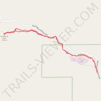
Occidental Peak Trail
- Distance: 3.3 Km
- Elevation gain: 159 m
- Maximum elevation: 1,709 m
- Elevation loss: 161 m
- Minimum elevation: 1,645 m
- Moving time: 1 h 39 m
- Moving speed: 2.0 Km/h
- Maximum speed: 5.6 Km/h
- Total time: 4 h 21 m
- Global speed: 0.8 Km/h
Interactive trail map
Trail profile
- Distance: 3.3 Km
- Elevation gain: 159 m
- Maximum elevation: 1,709 m
- Elevation loss: 161 m
- Minimum elevation: 1,645 m
- Moving time: 1 h 39 m
- Moving speed: 2.0 Km/h
- Maximum speed: 5.6 Km/h
- Total time: 4 h 21 m
- Global speed: 0.8 Km/h
About this trail
Name: Occidental Peak Trail trail, distance, elevation, map, profile, GPS track
Coordinates: 34.23069 -118.08377 34.23570 -118.07097
Other hiking, mountain biking, running and outdoor activity trails
Click on a trail to view its statistics, map and profile.
Gabrielino Trail
United States > California > Los Angeles County
Starting from Chantry Flat, the Gabrielino Trail slips from the shaded ridge above Big Santa Anita Canyon into a classic Angeles National Forest corridor of wooded slopes, creekside cabins and canyon-bottom shade. The route passes the lower canyon junctions, Cascade Picnic Area and Spruce Grove Trail Camp…
Distance: 44.4 Km • Elevation gain: 2,358 m • Maximum elevation: 1,421 m