The County Marathon
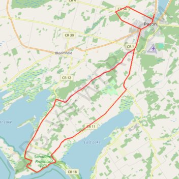
Interactive trail map
Trail profile
- Distance: 42.0 Km
- Elevation gain: 141 m
- Maximum elevation: 114 m
- Elevation loss: 142 m
- Minimum elevation: 74 m
About this trail
Name: The County Marathon trail, distance, elevation, map, profile, GPS track
Coordinates: 43.89820 -77.26999 44.02045 -77.13691
Other hiking, mountain biking, running and outdoor activity trails
Click on a trail to view its statistics, map and profile.
Cobourg - Adolphustown
Canada > Ontario > Northumberland County > Cobourg
Lake Ontario. #Bike #Cobourg #Adolphustown #Ontario
Distance: 114.3 Km • Elevation gain: 449 m • Maximum elevation: 119 m