Capitol Gorge
Hike in Capitol Gorge via Capitol Gorge Trail, Pioneer Register and Tanks Trail in the Capitol Reef National Park. #Hiking #Canyon #Park #Nature #Rock
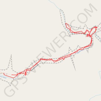
- Distance: 4.8 Km
- Elevation gain: 333 m
- Maximum elevation: 1,727 m
- Elevation loss: 336 m
- Minimum elevation: 1,643 m
- Moving time: 1 h 27 m
- Moving speed: 3.3 Km/h
- Maximum speed: 19.4 Km/h
- Total time: 1 h 35 m
- Global speed: 3.0 Km/h
Interactive trail map
Trail profile
- Distance: 4.8 Km
- Elevation gain: 333 m
- Maximum elevation: 1,727 m
- Elevation loss: 336 m
- Minimum elevation: 1,643 m
- Moving time: 1 h 27 m
- Moving speed: 3.3 Km/h
- Maximum speed: 19.4 Km/h
- Total time: 1 h 35 m
- Global speed: 3.0 Km/h
About this trail
Name: Capitol Gorge trail, distance, elevation, map, profile, GPS track
Start: Capitol Gorge Trail, Wayne County, Utah, United States (38.20942 -111.16802)
End: Golden Throne Trail, Wayne County, Utah, United States (38.20960 -111.16912)
Coordinates: 38.20907 -111.16912 38.21511 -111.15601