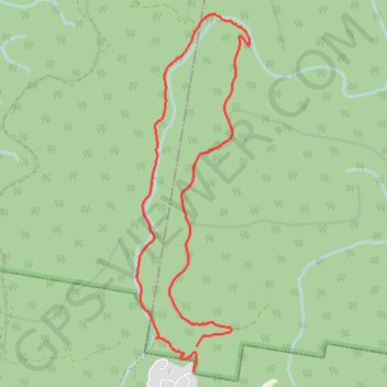
Blue Gum Swamp Track - Shaws Ridge Trail Trail
Blue Mountains National Park. #Hiking #Loop #BlueMountains
- Distance: 8.7 Km
- Elevation gain: 149 m
- Maximum elevation: 314 m
- Elevation loss: 134 m
- Minimum elevation: 229 m
- Moving time: 1 h 1 m
- Moving speed: 8.5 Km/h
- Maximum speed: 14.5 Km/h
- Total time: 1 h 1 m
- Global speed: 8.5 Km/h
Interactive trail map
Trail profile
- Distance: 8.7 Km
- Elevation gain: 149 m
- Maximum elevation: 314 m
- Elevation loss: 134 m
- Minimum elevation: 229 m
- Moving time: 1 h 1 m
- Moving speed: 8.5 Km/h
- Maximum speed: 14.5 Km/h
- Total time: 1 h 1 m
- Global speed: 8.5 Km/h
About this trail
Name: Blue Gum Swamp Track - Shaws Ridge Trail Trail trail, distance, elevation, map, profile, GPS track
Coordinates: -33.66435 150.60541 -33.63456 150.61664
Other hiking, mountain biking, running and outdoor activity trails
Click on a trail to view its statistics, map and profile.