Arch Rock and Heart Rock via Arch Rock Trail in Joshua Tree National Park
The Arch Rock Trail in Joshua Tree National Park offers a brief but captivating hiking experience, taking visitors through a vast landscape of unique rock formations and desert terrain. Along the way, hikers encounter the renowned Arch Rock, a natural rock arch that stands as a striking feature of the park, while a side detour reveals the heart-shaped formation of Heart Rock, adding a whimsical touch to the route. #Hiking #Rock #Desert #Nature
- Distance: 2.5 Km
- Elevation gain: 34 m
- Maximum elevation: 1,193 m
- Elevation loss: 34 m
- Minimum elevation: 1,166 m
- Moving time: 36 m 21 s
- Moving speed: 4.2 Km/h
- Maximum speed: 5.9 Km/h
- Total time: 43 m 54 s
- Global speed: 3.5 Km/h
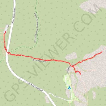
Interactive trail map
Trail profile
- Distance: 2.5 Km
- Elevation gain: 34 m
- Maximum elevation: 1,193 m
- Elevation loss: 34 m
- Minimum elevation: 1,166 m
- Moving time: 36 m 21 s
- Moving speed: 4.2 Km/h
- Maximum speed: 5.9 Km/h
- Total time: 43 m 54 s
- Global speed: 3.5 Km/h
About this trail
Name: Arch Rock and Heart Rock via Arch Rock Trail in Joshua Tree National Park trail, distance, elevation, map, profile, GPS track
Coordinates: 33.98622 -116.02298 33.98969 -116.01352
Other hiking, mountain biking, running and outdoor activity trails
Click on a trail to view its statistics, map and profile.
Arch Rock Trail in Joshua Tree National Park
United States > California > Riverside County
The Arch Rock Trail in Joshua Tree National Park offers a brief yet rewarding hike, leading to the park's renowned Arch Rock. Along the way, hikers can observe unique rock formations, including the distinctive white tank boulders, and a variety of desert flora such as creosote bushes, ocotillo plants, various…
Distance: 2.1 Km • Elevation gain: 26 m • Maximum elevation: 1,193 m